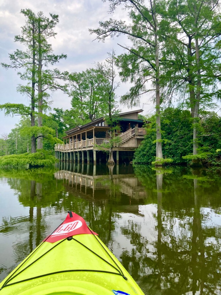
Although we all call Rye home, most of us aren’t from here. We hail from all over the world, often finding our way through New York as so many before us. “Home” becomes a nuanced term when you’re not from where you call it, especially when you’ve started your own family whose home it is. Going home for me is going to Monroe, Louisiana. As in any homecoming, it’s full of boozy meals with relatives and friends, late-night catchup chats and sleeping in your old room. But each time I go, I discover something new. I treat it like I treated Rye upon my arrival, a new place waiting to be explored. This last trip home I explored the waters of Bayou DeSiard. I’ve known it my whole life, learning to ski and drive a boat and spending lazy summers lounging in its warm waters. But I had only known a small part of it, tamer than the rest. We stayed away from the snaky parts and the gators. This trip I tackled other sections, going as far as I could, dam to dam. One can now rent a kayak from an outfitter and “put in at the bait shop across from the college.” There’s also a federal wildlife refuge at Black Bayou Lake offering canoe tours. AND I found a man with a fan boat. There’s more than one way to skin a cat.
When seen from above, the twisty turning bayou looks like the thick black snakes hidden in its folds. DeSiard begins north of Monroe, receiving inflow from Bayou Bartholomew (the longest bayou in the world at 364 miles) and Black Bayou Lake. It flows through town where it’s domesticated by manicured lawns and gorgeous homes, then dumps into the Ouachita River which creates the western border of town. It too creates a veined pattern with its constant turns and bends as it flows south from Arkansas. Our family’s piece of heaven, Riverbend, lies on its banks just north of town.
Monroe is between the Mississippi and the Ouachita Rivers about 300 miles north of the Gulf of Mexico. It’s on the southwestern edge of The Lower Mississippi Valley, the world’s third largest watershed which drains 41% of the United States. There is a “Before” and “After” scenario which inadvertently shaped everything in this area: The Great Flood of 1927. In April 1927 heavy rainfall pounded the area for days and the river rose accordingly. The first levee on the Mississippi broke along the Illinois shore on April 16 then at Mounds Landing in Mississippi on April 21. Over the next few weeks, the entire levee system along the Arkansas and Mississippi Rivers collapsed, submerging 23,000 square miles and displacing an estimated 750,000 people. The waters didn’t drain for two months, leaving countless lives ruined and 250 dead. On a positive note, the flood also ushered in long-term social and political changes in the country, contributing to the Great Migration of African Americans from the South to cities in the North.
Man responded with The Flood Control Act of 1928, creating the Mississippi River and Tributaries Project, “a comprehensive, unified system of public works within the lower Mississippi Valley that would provide unprecedented flood risk management and an equally efficient navigation channel”. The MR&T has four major features: levees and floodwalls, channel improvement and stabilization, tributary basin improvements and floodways. Translated into English this means new levees and dams were constructed by the Army Corps of Engineers and maintained by local levee boards and drainage districts from Illinois to Louisiana. The character of the land was forever altered. This system is still in place, with flood mitigation its top priority. Levee boards and drainage districts are charged with keeping rivers OUT of the towns, while local police juries and municipalities mitigate interior flooding. That’s a very simplistic explanation for a complicated system. It all makes for some very fine drama.
I’ve always heard that during the Great Flood one could paddle a canoe from Vicksburg to Monroe (80 miles), but it was factually flooded by a combination of events which included the breach of the Arkansas River levee above the state line and the backing up of water at the Three Rivers Area: the Ouachita, the Red and the Black. The Delta is so flat that with heavy rainfall, especially a stalled front, the water pools up. It has nowhere to go, and it backs up into the waterways north of it – bayous, lakes, rivers, ditches. Water seeks its own level. Monroe is at 72 feet above sea level while New Orleans is at one to two feet below sea level. That’s not much of a slope over 282 miles.
Water is a main character in the ongoing Southern Gothic drama that is Louisiana. Everyone knows Water. It sets the stage. We always know how high or low the river is and what flood or drought will bring. We feel it in the cypress trees and the Spanish moss. We hear it in the splash of an unknown creature jumping up then returning to lurk beneath the surface. We smell it in the faintly rotten tang of the bayou infused with the blooming waterlilies. We see it in the people who inhabit its banks. Now when I’m on the bayou, I connect the dots. It was awesome to ski at night with a beer in my hand when I was 16, clueless to what lay beyond. I knew every inch of that three-mile portion of bayou, every turn and tree and dock. But now I think Big Picture.
“For now we see through a glass, darkly;
but then face to face.
Now I know in part,
but then shall I know
even as also I am known.”
When we see clearly, we realize that people seek their own level, just like water. We all find where we belong.
ADDITIONAL READING:
Rising Tide by John M. Barry
The Gulf: The Making of an American Sea by Jack E. Davis
Lanterns on the Levee by William A. Percy

Leave a reply to Kiwi Cancel reply